There’s some land between Croatia and Serbia that neither country wants. It’s a very long story, this picture explains it best:

The Danube river was once the largest part of the northern border of the Roman Empire. Marcus Aurelius crossed it to beat up the Marcomanni and Quadi, and during these battles he wrote his Meditations. Quite a long time later, the Slavs migrated into the Balkans. A long time after that, a country called Yugoslavia broke up into a bunch of South Slav countries that hated each other, despite generally being regarded as very similar by outsiders. Perhaps familiarity breeds contempt. The point is that many of these new countries interpreted previous, sometimes vague border claims to give themselves as much land as possible, as nation-states tend to do.
The stuff in yellow is what Croatia claims, based off of the original course of the Danube. Serbia also claims the yellow stuff, saying that the border is the current course of the Danube. Both countries want to stick to those exact claims to the letter, since that gives them more land wherever the river moved west. But what about where the river moved east? Neither country claims it. This probably means that the territory is in limbo and will be awarded to one of the two countries in international arbitration. But that’s not a fun interpretation: the fun interpretation is that it’s terra nullius, and thus literally free real estate for the first yokel that plants a flag on it.

One such group of yokels is Liberland, who want to build a right-leaning libertarian state, as opposed to the right-authoritarian to left-center political “axis” that forms most modern political dialectic. “Socially liberal and fiscally conservative,” all that jazz that sounds moderate but nobody votes for so they try to claim unused lands like this or build artificial islands in the South Pacific. It’s a pioneering spirit that’s also very pessimistic.
These yokels need a plan for their city, but hate central planning and have a parcel of land on the flood plain of one of Europe’s biggest rivers. It’s all a bit of a contradiction in terms. To some degree, central planning is needed for the sole purpose of flood mitigation — it’s a classic example of the Tragedy of the Commons. It’s easy for individuals to take no flood prevention measures, since they cost time and money, but if no one does, everyone suffers in the long term. Obviously, some sort of plan is needed to keep everyone nice and dry in a relatively decentralized manner.
Additionally, the long-term goal is no urban planning at all, no dedicated zoning, and near-total private ownership of all landmass in the Siga area. This is an admirable end goal, but like nearly all utopian schemes, there must be a “jumping off point” from where what we know may enter the unknown.
You can measure the feasibility of any such scheme by the roadmap leading to it — is it through incremental policy changes or over hills of bodies? Human nature doesn’t quickly change, and we mustn’t ask or expect it to. Therefore, conventionality should be preferred over what is drastic.
Ease of property differentiation should also be preferred, initially. When the land is yet to be developed, mere plots on a map, there are bound to be property disputes. By making initial plots purposefully simple polygons, we can enable GPS coordinate verification of property, which will cut down on non-frivolous arbitration.
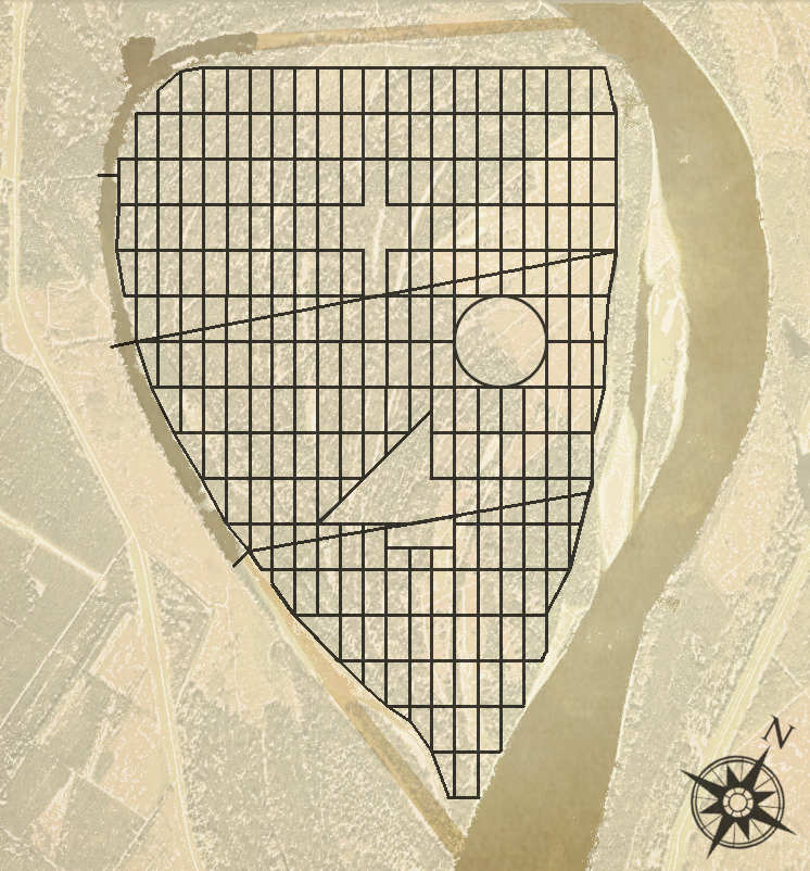
How I’d build it: initial 100 by 200 meter blocks, something of a standard in many cities and allows for small and large developments. Taking a page from the L’Enfant plan for Washington, DC, I’ve also taken the liberty (ha) of tilting the plan so it’s not quite along a north-south access, but can then be carved out so that the result looks like the seal for itself.
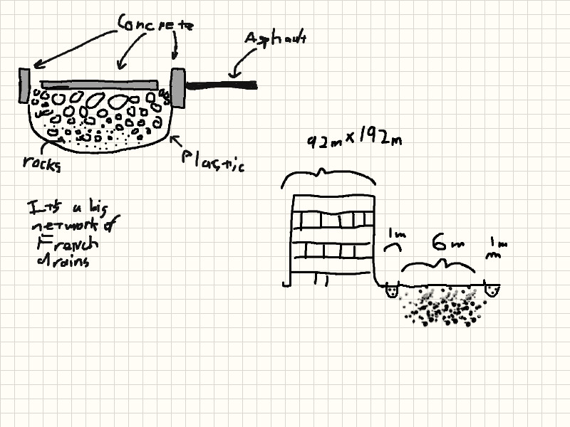
The roads can also be used as part of a larger drainage/flood mitigation system as illustrated in this diagram, based on work already outlined in Seattle’s experiments in sidewalk design and basic french drain systems.
Also, some levels of levees will need to be used, as the carrying capacity of these french drains will not stay all waters. If there is a “central power company”, or something that we could roughly describe as analogous, they will likely run pumps for their own benefit as well as the land around them.
A system of levees along the bank will probably also be needed, with earth extracted from the Croatian side. Theoretically, this will be something of a channel where the excess water is pumped to to get it away from the city and downstream.
I was doing this all for a contest they were holding, but that contest was cancelled, so here’s this short write-up on all I had done before then.
Freely,
John